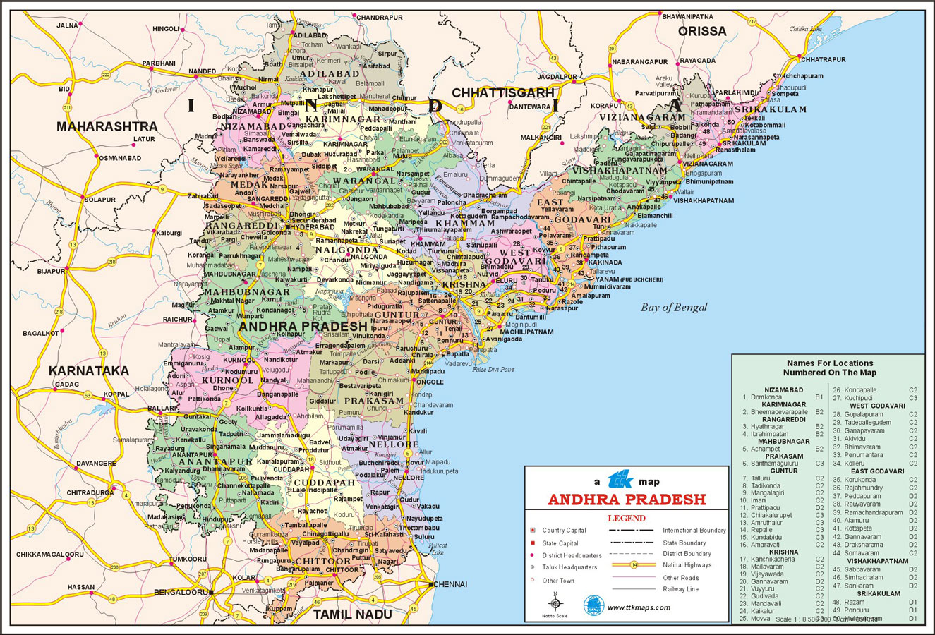
Andhra Pradesh after bifurcation on 2nd June, 2014 has now 13 districts. There were 23 districts in the combined Andhra Pradesh. After separation of Telengana as a separate state with 10 districts, Andhra Pradesh has now 13 districts. Now Andhra Pradesh is one of the 29 states of India. Ananthapur district is the largest district in Andhra Pradesh and Srikakulam is the smallest district. The total districts of Andhra Pradesh are divided into two regions.
Here is the list of districts of Andhra Pradesh.
1. Srikakulam District : The Srikakulam district has the longest coast line in Andhra Pradesh.. Nagavali and Vamsadhara rivers flows through this district. The Srikakulam district was created out of part of Vishakapatnam district on 15th August, 1950.
Krishna District with its headquarters at Machilipatnam was formerly called Machilipatnam District. Later on it was renamed as Krishna district by adding certain taluks of the abolished Gutur district in 1859 with Machilipatnam as its headquarters. It was named after Krishna river which is the third longest river in India. The river flows in Andhra Pradesh before it empties itself into Bay of Bengal near Hamsaladevi village in Krishna district.
The borders of Krishna District are West Godavari district in east, Bay of Bengal in the south, Guntur district and Nalgonda district ( Telengana state ) in West and Khammam district ( Telengana state ) in north directions.
- The Coastal Andhra comprises of 9 districts namely, Srikakulam, Vizianagaram, Visakhapatnam, East Godavari, West Godavari, Krishna, Guntur, Prakasham and Sri Potti Sriramulu Nellore.
- The Rayala Seema region comprises of 4 districts - Kurnool, Chittor, YSR Kadapa and Ananthapur districts.
Here is the list of districts of Andhra Pradesh.
1. Srikakulam District : The Srikakulam district has the longest coast line in Andhra Pradesh.. Nagavali and Vamsadhara rivers flows through this district. The Srikakulam district was created out of part of Vishakapatnam district on 15th August, 1950.
The district was situated between 83º 25' and 84º 50'E, of the eastern longitudes and 18º 20' and 19º 10'N, of northern latitudes. The boundaries of this district are Bay of Bengal in the East, Vijayanagaram district in the South and Orissa state borders in the West and North directions. The district has population of 26,99,471 as per the 2011 census .
Head Quarters: Srikakulam
2. Vizianagaram District : If India is a land of precious stones, one such jewel embedded on Indian soil is the Vizianagaram district. The battle of Bobbili and the battle of Padmanabham are unforgettable and make the area the land of pride and valour. The district is situated between 83º 0' and 83º 45'E, of the eastern longitudes and 17º 15' and 19º 15'N, of northern latitudes. The Boundaries of this district are Srikakulum district in the East, Vijayanagaram district in the South, Orissa state and Vishakapatnam district in the West and Orissa state in the North directions. The district has population of 23,42,868 as per the 2011 census.
Head Quarters: Vizianagaram
3. Visakhapatnam District : Visakhapatnam is a coastal city also called as the "Jewel of the East Coast". situated in Andhra Pradesh. The Visakhapatnam is situated on eastern coast of India, and nestled among the hills of Eastern Ghats and facing the Bay of Bengal to the east.
Visakhapatnam is the largest city in Andhra Pradesh with an area of 550 square kilometers and is an industrial city apart from being aport city. It is the head quarters of Eastern Naval Command. The district is situated between 81º 06' and 83º 31'E, of the eastern longitudes and 17º 15' and 18º 32'N, of northern latitudes. The boundaries of this district are Bay of Bengal in the East, East Godavari district in the South, Orissa state in the West and North directions. The district has population of 42, 88,113 as per the 2011 census.
Head Quarters: Visakhapatnam
4. East Godavari district : The East Godavari is a district in Coastal Andhra region and the district Head Quarters is located at Kakinada. The district is the most populous district in Andhra Pradesh with a population of 51,51,549 as per 2011 census. Rajahmundry and Kakinada are the largest two cities in this district. The East Godavari is also called as Rice Bowl of Andhra Pradesh with lush paddy fields and coconut groves.
East Godavari district has a total area of 10,807 sq. kilometers. This district is a residuary portion of the old Godavari district after separation of West Godavari in 1925. East Godavari is closely associated with the river Godavari. The district has 5 revenue divisions, 60 revenue mandals and 1012 Grama Panchayats.
East Godavari district is situated between 81º 30' and 82º 36'E, of the eastern longitudes and 16º 30' and 18º 20'N, of northern latitudes. The boundaries of the districts are Visakhapatnam district and Orissa state on north side, the Bay of Bengal on east side, the West Godavari district on west side, and Khammam district on north west.
East Godavari district is situated between 81º 30' and 82º 36'E, of the eastern longitudes and 16º 30' and 18º 20'N, of northern latitudes. The boundaries of the districts are Visakhapatnam district and Orissa state on north side, the Bay of Bengal on east side, the West Godavari district on west side, and Khammam district on north west.
Head Quarters: Kakinada
5. West Godavari district : This is one of the 13 districts of Andhra Pradesh lying in coastal andhra region. The district headquarters is located at Eluru. The district population is 39,34,782 as of 2011 census. The total area of this district is 7,742 sq. kms.
The West Godavari is extremely fertile, getting water abundantly through out the Cotton barrage built on the Godavari River at Dhavaleswaram. Topographically the district is divided into the Delta and the uplands.
Agriculture, coconut and rice are cultivated in delta region. The district is popularly known as the Granary of India since about 50% of the state's rice production comes from this district. Oil palm, sugar cane, mango, banana and other fruits as well as tobacco and cotton are produced in the uplands region. Prawns and fish are exported to Japan and USA from the coastal belt of the district. Eluru is the largest city in West Godavari district with woolen carpet industry. Tadepalligudem is the biggest market center and is the geographical center of the district. The Tanuku has Andhra Sugars.
Head Quarters: Eluru
6. Krishna district : This is one of the 13 districts of Andhra Pradesh lying in coastal andhra region. The district headquarters is located at Machilipatnam. The district population is 45,29,009 as of 2011 census. The total area of this district is 8,727 sq. kms.
Krishna District with its headquarters at Machilipatnam was formerly called Machilipatnam District. Later on it was renamed as Krishna district by adding certain taluks of the abolished Gutur district in 1859 with Machilipatnam as its headquarters. It was named after Krishna river which is the third longest river in India. The river flows in Andhra Pradesh before it empties itself into Bay of Bengal near Hamsaladevi village in Krishna district.
The borders of Krishna District are West Godavari district in east, Bay of Bengal in the south, Guntur district and Nalgonda district ( Telengana state ) in West and Khammam district ( Telengana state ) in north directions.
The population of the Krishna District is 41,81,071 persons. Among these persons, the males are 21,16,018 in numbers while females are 20,65,053 in numbers. The sex ratio is 961 females per 1000 males.
The Krishna district is endowed with a rich variety of soils and it occupies very important place in agriculture, which is the most important occupation in the district. Paddy is the main food crop produced in this district. The literacy rate of Krishna district is 70.03 % which indicates that the district is well advanced in the field of education.
Vijayawada is the major city in Krishna district and it has an important railway junction which is connected to Delhi, Calcutta, Chennai, Hubli, Gudiwada and Machilipatnam. The largest bus station in the state is also located in Vijayawada.
The Krishna district has a large number of Tourist Spots like:
- Bhavani Island Leisure Spots Vijayawada
- Gandhi Hill Monuments Vijayawada
- Ghantasala Buddhist Centres Ghantasala
- Hazrat Bal Mosque Pilgrim Centres Vijayawada
- Jaggayyapeta Buddhist Centres Jaggayyapeta
Head Quarters: Machilipatnam
There are totally 13 districts... the information about other districts will be posted soon...